Soluções Tecnológicas de dados de Geociência em SIG aplicada

Inovação e Criatividade em Projectos de Engenharia Multidisciplinares.

Levantamento e coordenação de pontos de planimetria.

Planeamento qualificado para projectos de infraestrutura.

Licenciamento e formação em ArcGIS Pro.

A geothermal landscape with a pool of water in the foreground surrounded by rock and soil. Steam rises gently from the surface, blending with the cloudy sky. The horizon shows distant mountains under a pale blue sky, creating a serene and expansive view.
A solar panel is positioned on a large rock near a body of water, suggesting energy harnessing in a natural setting.
A geothermal scene featuring a vibrant hot spring with clear blue water and mineral deposits. Rising steam indicates hot temperatures, while the perimeter displays an array of colors from yellow to brown, blending into the white mineral crust. Beyond the spring, evergreen trees and a blue sky complete the landscape.

Quem somos nós

Na Oceangeo, SA, oferecemos soluções tecnológicas em geociência, atuando em energia, água, recursos minerais, petróleo e topografia. Nossa equipe é composta por profissionais dedicados e criativos.

12+

15+

Clientes satisfeitos

Projectos & Formações

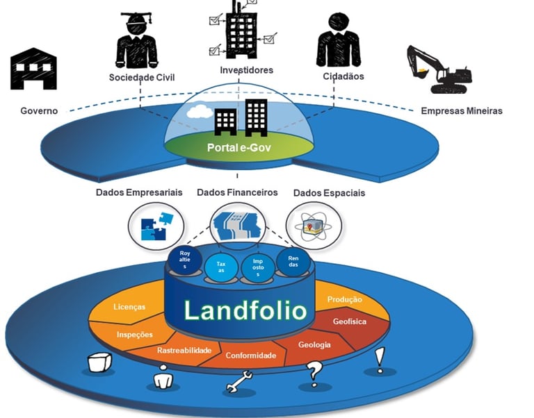
Soluções em Geociência

Tecnologia avançada para energia, água, recursos minerais e petróleo com foco em inovação.

Serviços de Topografia
A vast body of water extends across the foreground with a distant shoreline visible in the background. On the horizon, numerous wind turbines are spread across the landscape under a cloudy sky, suggesting renewable energy use.

Levantamento e coordenação de pontos de planimetria e altimetria com precisão.

Aerial view of a geothermal landscape with vibrant mineral deposits. Dominant features include a bright yellow and green pool on the left with branching patterns extending across the surface. Pale blue and white mineral formations create a stark contrast with the muted brown and gray earth tones.
An aerial view showcasing a landscape with large water bodies, possibly reservoirs or ponds, surrounded by agricultural fields. There are solar panels installed in rows, several long buildings possibly used for processing, and clusters of trees providing greenery amid predominantly dry terrain.
Planeamento Eficiente

Integração de técnicas qualificadas para projectos multidisciplinares e soluções criativas.

Formação e Criatividade

Desenvolvimento de soluções inteligentes.

Projectos Geocientíficos

Soluções tecnológicas em geociência para energia e água.

A landscape featuring a large solar panel array in the foreground, with a modern wind turbine to the left. Behind the renewable energy installations, an industrial facility with multiple chimneys and storage tanks is visible under a clear blue sky.
Topografia Avançada

Levantamento e coordenação de pontos de planimetria.

An aerial view of a geothermal landscape with steam vents and patches of white mineral deposits. The area is predominantly brown with various shades, interspersed with white and blue on one side, indicative of snow or frost. There are several circular formations suggesting volcanic activity.
A scenic landscape with lush green hills and evergreen trees under a bright blue sky. In the foreground, geodesic domes sit amidst dry grass and a large boulder. Overhead, power lines stretch across the scene.
Clear, shallow water with smooth pebbles visible beneath the surface. In the background, a line of wind turbines is situated on a grassy landscape, with mountains partially covered in snow under a blue sky with scattered clouds.
Planeamento Eficiente

Integração de técnicas qualificadas para projetos inovadores.

Contacto

A satellite is positioned over a coastal landscape, highlighting a stark contrast between the deep blue ocean and the arid, brown rocky terrain. The satellite features a large solar panel array and is centered in the image, capturing both natural and technological elements.

Entre em contacto para soluções em geociência, topografia, licenciamento e planeamento de projectos personalizados.